 |
|
This section is about GIS (Geographic Information Systems) and what they mean for voter projects. As you will learn from the videos in this section, maps are great tools for transmitting complex information in quickly understood formats. Putting your member file on a map will help you see where there are concentrations that might make good target areas for your voter project. As Robby says “It helps people to visualize the importance of the precinct-based level infrastructure that we’re trying to build.”
The field is changing on a monthly basis and software applications that were too complex or expensive are now becoming easier to use and cheaper, but a word to the cautious is in order. This stuff is complicated. You will find it best to work your way into the mapping world a little at a time. If you are starting from scratch, absolutely get some help and don't do it yourself. Our tip is that you enlist people from your nearest university geography department. You're likely to find interns eager to use their new skills. After you've worked with it for while, you'll need to evaluate whether you should do mapping in-house or not. While you certainly can master it, unless your organization has a strategic reason for learning GIS, most organizing groups would be better off recruiting someone to provide maps as needed.
The two major ingredients for creating a useful map are good data and mastery of mapping software to manipulate them. The process of mapping involves getting a data file that is geocoded, which simply means that the addresses in the file have had geographic coordinates added to them, and then feeding that into mapping software to display on a map. Since you will certainly be using a voter file and probably using your member file, both should be geocoded. Some software can geocode your database directly from the addresses. Microsoft's Mappoint, which runs on your compute,r and Google Maps, which runs on the internet, are examples of this software.
So you get your members and voters plotted on a map, then what? In the planning section we covered the types of targeting in a voter project. The point of targeting is to find the best place to put your energies. And this is where a good map can help you. But you'll need some more information on your map to really evaluate your options. For instance, if you organize people of a specific ethnicity and/or income level, you'll want to plot that information on your map.
One public source is the U.S. Census. However, census tracts and census blocks - the geographic units that the data comes in - do not correspond to precincts, which are the geographic political jurisdictions. This means that the ethnicity and income level for a precinct - or voter - can only be approximated from census information. There are private datasets that have consumer information about individuals that is used in commercial direct marketing and that can be aggregated for neighborhoods, but they are prohibitively expensive for most community organizing groups' voter projects. In many locations you can have a vendor analyze the registered voter files by ethnicity. This is a far from perfect process where last names are compared to lists of names that are typically associated with Latinos or Chinese, for instance. The result is a guess at the ethnic makeup of the precinct.
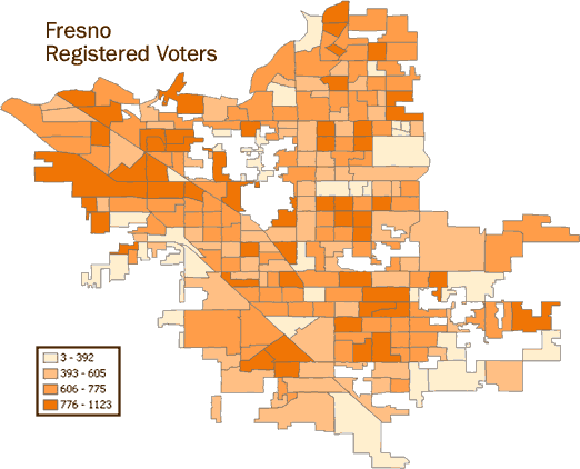
The following maps of Fresno California will give you a sense of how this type of data can be presented for analysis. The first map simply shows the density of voter registration by precinct. This tells you where the existing voting population is. A variant on this map might be to use the voting history records to show where the occasional voters live.
The map below shows the concentrations of Latino registered voters. The table with it shows how many are in each election district and their percentage of the overall total. Combine this information with the percentage of occasional voters and the location of an organization's membership to get a sense of which are the best target precincts.
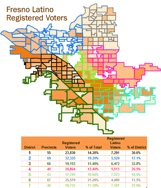
Data Source: Statewide Database, University of California
Click to hear from an organizer
 Robby Rodriguez: "It helps people to visualize the importance of the precinct-based level infrastructure that we’re trying to build."
 Anthony Thigpenn: We use GIS to do the design, strategy and targeting